MS Roald Amundsen - Antarctic Circle Expedition
MS Roald Amundsen pushes far beyond the standard Peninsula run on this Ushuaia roundtrip, crossing the Antarctic Circle at 66°33'S and probing seldom-visited Marguerite Bay — territory reached by only a fraction of Antarctic voyages.
Price Range
$$$$$
Ultra-Luxury
*Prices vary by cabin type, sailing date, and availability. Confirm rates with Hurtigruten before booking.
Ship Details — MS Roald Amundsen
View full MS Roald Amundsen details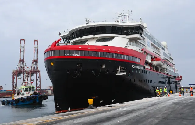
Year Built
2019
Tonnage
20,889 GT
Passengers
530
Crew
151
Decks
8
Class
Expedition
Itinerary & Route Map
Loading map…
Where this cruise calls, day by day
13 ports and 4 sea days over 16 Nights.
- Day 1
Ushuaia
ArgentinaDepartUshuaia sits on the Beagle Channel below the Martial range and bills itself as the world's southernmost city, which is mostly true and entirely commercial. It is the main embarkation port for Antarctic expedition ships, so the waterfront is a mix of outfitters, king crab restaurants and gangways. Passengers on round-South-America itineraries usually get a half day for the national park or a channel boat trip.
- Tierra del Fuego National Park and Lapataia Bay
- Beagle Channel catamaran trip to Les Eclaireurs lighthouse and the sea lion islets
- End of the World Train (Tren del Fin del Mundo)
- Museo del Presidio, the old prison that built the town
- Getting ashore
- Ships berth at the Muelle Comercial, a short walk from Avenida San Martin.
- Best months
- Nov-Mar
Day 2 · At sea
Day 3 · At sea
- Day 4
Half Moon Island (South Shetlands)
AntarcticaPortA crescent of rock and shingle about a mile across, tucked into the eastern side of Livingston Island, and for many ships it is the first Antarctic landing of the trip. The chinstrap colonies are spread over rocky outcrops behind the beach, and Argentina's Camara Base sits at one end, usually shuttered. Across the water the glaciated Burgas mountains of Livingston fill the horizon.
- Chinstrap penguin colonies on the rock outcrops
- Argentina's Camara Base
- Weddell seals hauled out on the shingle
- Views across to Livingston Island's icefields
- Getting ashore
- Zodiac landing on a shingle beach, weather permitting.
- Best months
- Nov-Mar (Antarctic season)
- Day 5
Neko Harbour
AntarcticaPortNeko Harbour is one of the few places where passengers set foot on the Antarctic mainland rather than an offshore island, which is why expedition leaders push hard to make it happen. There is a gentoo colony on the rocks, an Argentine refuge hut, and a hill behind the beach that gives a view over Andvord Bay. The glacier at the head of the harbour calves regularly, and staff keep everyone well up the beach because the wave that follows is not theoretical.
- Continental landing on the Antarctic mainland
- Gentoo penguin colony above the landing beach
- The viewpoint climb over Andvord Bay
- Calving face of the Neko glacier
- Getting ashore
- Zodiac landing, weather and ice permitting; landings are cancelled often.
- Best months
- Dec-Feb (chicks visible from late December)
- Day 6
Paradise Bay
AntarcticaPortWhalers named this bay, and for once the name holds up — it is a sheltered basin of glacier fronts and floating brash on the peninsula's west coast. Two research stations sit on its shores, Argentina's Almirante Brown and Chile's Gonzalez Videla at Waterboat Point, and one of them is usually the excuse for a landing. Most of the time here is spent in zodiacs, drifting under ice cliffs and watching for calving.
- Almirante Brown Station and the hill climb behind it
- Gonzalez Videla Station at Waterboat Point, with gentoos nesting between the buildings
- Skontorp Cove's ice cliffs and blue-eyed shag colony
- Zodiac cruising among grounded bergs
- Getting ashore
- Zodiac landing or zodiac cruise depending on ice and swell; there is no pier.
- Best months
- Nov-Mar (Antarctic season)
- Day 7
Lemaire Channel (Scenic Cruising)
AntarcticaPortA seven-mile slot between Booth Island and the Graham Land mainland, barely a mile wide at its narrowest, with cliffs going straight up on both sides. Photographers nicknamed it Kodak Gap for good reason: on a still day the water mirrors the walls and everyone is on deck. Ice frequently blocks the southern end, in which case the captain reverses out and nobody gets the picture.
- The twin spires of Cape Renard at the northern entrance
- Booth Island's ridgeline rising directly off the port rail
- Crabeater seals hauled out on drifting floes
- Reflections in the channel on a windless morning
- Getting ashore
- Scenic cruising only — no landing, and the transit is abandoned if pack ice fills the channel.
- Best months
- Dec-Feb (ice usually clears later in the season)
- Day 8
Petermann Island
AntarcticaPortA low, rocky island just south of the Lemaire Channel with a long history — Charcot's Pourquoi Pas? wintered here in 1909, and an Argentine refuge hut still stands above the landing. Gentoos and Adelies nest side by side, which makes it a good place to see the difference between the two. Blue-eyed shags hold the higher rocks. It sits far enough south that ice sometimes keeps ships out.
- Mixed Adelie and gentoo colonies, one of the few sites with both
- The Argentine Groussac refuge hut
- Blue-eyed shag colony on the higher ground
- Charcot's 1909 wintering site at Port Circumcision
- Getting ashore
- Zodiac landing when ice and swell allow; the island is often bypassed.
- Best months
- Dec-Feb
- Day 9
Antarctic Circle Crossing (Scenic Cruising)
AntarcticaPortCrossing 66 degrees 33 minutes south is a line on a chart rather than a place, and only a minority of Antarctic itineraries go far enough to do it. The reward is thinner: fewer ships, more sea ice, and a genuine sense of the continent's scale. Expect a deck announcement, a certificate and usually a toast in something cold. Whether the ship can get there at all comes down to how far north the pack ice is sitting that season.
- The formal crossing announcement and certificate
- Heavier sea ice and larger floes than further north
- Crabeater seals, which favour the pack ice
- Marguerite Bay and Adelaide Island on longer southbound voyages
- Getting ashore
- No landing — this is a position, not a site; ice conditions often stop ships short.
- Best months
- Feb-Mar (best chance the ice has retreated far enough)
- Day 10
Horseshoe Island (Marguerite Bay)
AntarcticaPortHorseshoe Island lies in Marguerite Bay, well south of the Antarctic Circle, ringed by mountains that give it the name. Base Y, a British station occupied from 1955 to 1960, still stands with its bunks, tinned food, tools and radio gear more or less as they were left — it is Historic Site No. 63 and one of the best-preserved bases on the continent. The landing is usually at Sally Cove with a short walk to the hut.
- Base Y hut, preserved with its 1950s fittings intact
- Historic Site and Monument No. 63, managed by UKAHT
- The horseshoe of 900-metre peaks around the island
- Marguerite Bay sea ice and its seals
- Getting ashore
- Zodiac landing at Sally Cove; only far-south itineraries reach it, and sea ice frequently prevents access.
- Best months
- Feb-Mar
- Day 11
Stonington Island (Marguerite Bay)
AntarcticaPortStonington is a small rocky island in Marguerite Bay that once connected to the mainland by an ice ramp, now gone. Two abandoned bases sit a couple of hundred metres apart: the American East Base from 1939-41 and the larger British Base E, occupied on and off until 1975. Both are protected historic sites. Stonington is also where Jackie Ronne and Jennie Darlington became the first women to overwinter in Antarctica.
- British Base E, Historic Site No. 64
- The American East Base ruins nearby, Historic Site No. 55
- Roman Four Promontory rising behind the bay
- Marguerite Bay ice and its Weddell and crabeater seals
- Getting ashore
- Zodiac landing on a far-south itinerary; sea ice in Marguerite Bay stops most attempts.
- Best months
- Feb-Mar
- Day 12
Hanusse Bay & The Gullet (Scenic Cruising)
AntarcticaPortThe Gullet is a narrow passage between the east end of Adelaide Island and the Graham Land mainland, connecting Hanusse Bay to Laubeuf Fjord. It is deep south, tight enough that ice cliffs loom over both rails, and blocked by fast ice more often than not — captains who find it open tend to make a point of it. When it isn't passable, ships try the Gunnel Channel instead or turn around.
- The narrows between Adelaide Island and the mainland
- Hanusse Bay's sea ice and grounded bergs
- Crabeater and Weddell seals on the floes
- Adelaide Island's mountains and the mainland ice cliffs
- Getting ashore
- Scenic cruising only, and often not possible at all — fast ice closes the passage in most seasons.
- Best months
- Feb-Mar (the only realistic window for open water)
- Day 13
Port Lockroy
AntarcticaPortBase A on Goudier Island was a British wartime station and is now a museum, gift shop and the southernmost post office in the world, staffed each summer by a handful of people who live there without running water. A gentoo colony nests around and under the buildings, and half the island is left undisturbed for a long-running study of how the birds cope with visitors. Post a card and it will reach home in a couple of months.
- Base A museum, restored to its 1950s fit-out
- The post office and the ceremonial postcard queue
- Gentoo penguins nesting among the huts
- Jougla Point nearby, with assembled whale bones
- Getting ashore
- Zodiac landing on a tiny island with a strict visitor cap; ships must book a slot in advance and calls are still lost to weather.
- Best months
- Nov-Mar (the base is staffed only during the austral summer)
- Day 14
Deception Island
AntarcticaPortDeception is a flooded volcanic caldera in the South Shetlands, and ships sail into the crater through a gap in the wall called Neptune's Bellows that looks far too narrow from the bow. Inside is Port Foster, a black-sand harbour ringed by ash slopes. Whalers Bay holds the rusted boilers and tanks of an abandoned whaling station and the wrecked remains of a British base, all half-buried by a 1969 eruption.
- Neptune's Bellows, the caldera entrance
- Whalers Bay's rusting boilers, tanks and the ruins of Base B
- Baily Head's very large chinstrap penguin colony (landing rarely possible)
- Geothermally warmed shallows at Pendulum Cove
- Getting ashore
- The ship sails inside the caldera and passengers go ashore by zodiac; swell at the entrance sometimes cancels the call.
- Best months
- Nov-Mar (Antarctic season)
Day 15 · At sea
Day 16 · At sea
- Day 17
Ushuaia
ArgentinaArriveUshuaia sits on the Beagle Channel below the Martial range and bills itself as the world's southernmost city, which is mostly true and entirely commercial. It is the main embarkation port for Antarctic expedition ships, so the waterfront is a mix of outfitters, king crab restaurants and gangways. Passengers on round-South-America itineraries usually get a half day for the national park or a channel boat trip.
- Tierra del Fuego National Park and Lapataia Bay
- Beagle Channel catamaran trip to Les Eclaireurs lighthouse and the sea lion islets
- End of the World Train (Tren del Fin del Mundo)
- Museo del Presidio, the old prison that built the town
- Getting ashore
- Ships berth at the Muelle Comercial, a short walk from Avenida San Martin.
- Best months
- Nov-Mar
Onboard Amenities
Cruise Highlights
About the Ship
What Travelers Say About MS Roald Amundsen
Reviews of the ship itself — the same for every MS Roald Amundsen sailing. Based on 600 discussions.
MS Roald Amundsen is Hurtigruten's (now HX) headline ship as the world's first hybrid-electric expedition vessel, with battery banks that cut fuel and CO2 by roughly 20% and make for very quiet sailing. The vibe is active, nature-first and Norwegian-cool - it draws travelers who care about wildlife, science and sustainability rather than nightlife, wrapped in stylish Scandinavian hygge interiors with granite, pale woods and full-height panoramic windows. At 530 guests (capped at 500 for Antarctica) it's on the larger side for an expedition ship, which is the central trade-off in nearly every review.
What People Love
- World's first hybrid-electric expedition ship - battery banks cut fuel and CO2 by about 20% and make sailing notably quiet
- Excellent expedition and science team with daily landings, Zodiac cruises and lectures, plus a standout Amundsen Science Center
- Stylish Scandinavian hygge design with granite, birch and wool throws that feels more upscale than many expedition ships
Common Complaints
- Large for an expedition ship (530 guests, capped at 500 in Antarctica), so it feels less intimate than small vessels
- Rotating landings under the IAATO 100-person cap mean some days you don't get ashore until midday or later
- Recurring complaint that it's a budget product marketed as luxury, with food and service not fully matching the premium positioning