MS Roald Amundsen - Alaska's Inside Passage Expedition
A one-way expedition from Whittier to Vancouver aboard HX's hybrid-electric MS Roald Amundsen, trading megaship ports for small-boat landings in Prince William Sound, Icy Bay, and Misty Fjords. Expedition teams lead kayaking, hikes, and wildlife watching for whales, bears, and bald eagles, with indigenous community visits in Klawock and Alert Bay.
Price Range
$$$$
Luxury
*Prices vary by cabin type, sailing date, and availability. Confirm rates with Hurtigruten before booking.
Ship Details — MS Roald Amundsen
View full MS Roald Amundsen details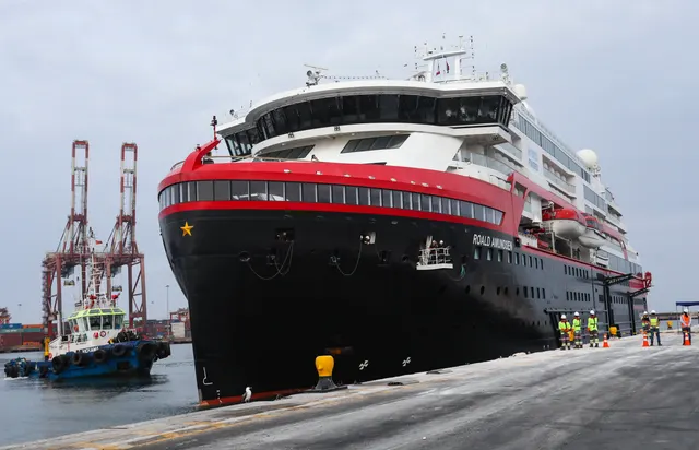
Year Built
2019
Tonnage
20,889 GT
Passengers
530
Crew
151
Decks
8
Class
Expedition
Itinerary & Route Map
Loading map…
Where this cruise calls, day by day
12 ports and 1 sea day over 12 Nights.
- Day 1
Whittier, AK
United StatesDepartWhittier is the strangest embarkation port in Alaska: a town of under 300 people who almost all live in a single 14-storey building, Begich Towers, reached by a one-lane tunnel bored through a mountain that cars and trains take turns to use. It exists as a port because the water is deep and Anchorage is 58 miles away. Nobody stays - you arrive, cross Prince William Sound, and go.
- Passing through the 2.5-mile Anton Anderson Memorial Tunnel, the longest combined road and rail tunnel in North America
- Glacier and wildlife day cruises into Prince William Sound from the small boat harbour
- The Buckner Building, a derelict WWII army barracks above the town
- The rail journey or coach transfer to Anchorage along Turnagain Arm
- Getting ashore
- Ships berth alongside; the town is tiny and walkable in minutes, and everything else means the tunnel or the train.
- Best months
- May-Sep (Jun-Aug; Whittier is notoriously wet and windy even in summer)
- Day 2
Prince William Sound
United StatesPortPrince William Sound is the sheltered, glacier-rimmed water between the Kenai Peninsula and the Chugach Mountains that Gulf of Alaska itineraries cross to reach Whittier or Valdez. Most ships spend the daylight hours in College Fjord, whose glaciers were named in 1899 after east-coast colleges by an expedition that put the women's colleges on one side and the men's on the other.
- College Fjord and the Harvard and Yale glaciers at its head
- Columbia Glacier, one of the fastest-retreating glaciers in the world
- Sea otters, which recovered here in numbers after the 1989 Exxon Valdez spill
- Chugach Mountains and tidewater ice on both sides of the transit
- Getting ashore
- Scenic cruising - the sound is crossed on the way to or from Whittier or Valdez, with no landing during the transit itself.
- Best months
- May-Sep (Jun-Aug; often overcast, and glacier viewing depends on cloud height)
- Day 3
Icy Bay
United StatesPortIcy Bay is a rare and genuinely remote scenic-cruising call on the Gulf of Alaska coast, west of Yakutat. The bay barely exists in historical terms - at the start of the 20th century its entrance was sealed by a single glacier face, and the retreat of the Guyot, Yahtse and Tyndall glaciers has opened the whole multi-armed inlet within about a century. Mount Saint Elias rises behind it.
- The calving faces of the Guyot, Yahtse and Tyndall glaciers at the heads of the arms
- Mount Saint Elias, over 18,000 feet, standing almost directly above the coast
- Icebergs and seals in water that was solid ice a lifetime ago
- Deck viewing on a coast with no settlements at all
- Getting ashore
- Scenic cruising only - no dock, no settlement, and how far in the ship goes depends on ice and weather.
- Best months
- Jun-Aug (a very exposed Gulf coast; calls are weather-dependent)
- Day 4Icy Strait Point port guide: where ships dock and what to do ashore
Icy Strait Point
United StatesPort - Day 5
Haines, AK
United StatesPortHaines is Skagway's quieter neighbour across Lynn Canal, and gets a fraction of the ships, which is most of its appeal. The town is built around Fort William H. Seward, a 1904 army post whose white officers' houses still ring the parade ground. It is one of only three Southeast Alaska towns connected to the continental road system, via the Haines Highway into the Yukon.
- Alaska Chilkat Bald Eagle Preserve along the Chilkat River flats
- Fort William H. Seward's parade ground and Hammer Museum in town
- Rafting or jet boat trips on the Chilkat, and bear watching at Chilkoot Lake
- Driving the Haines Highway up over the Chilkat Pass
- Getting ashore
- Ships berth at the Port Chilkoot Dock, a short walk from Fort Seward and about a mile from the main townsite.
- Best months
- May-Sep (Jun-Aug for river trips; the vast eagle gathering peaks Oct-Feb, after the cruise season)
- Day 6
Lynn Canal
United StatesPortDespite the name, Lynn Canal is not artificial - it is a natural fjord roughly 90 miles long and over 2,000 feet deep, among the deepest in North America. Ships transit it to reach Skagway and Haines at its head, where it splits into the Chilkat, Chilkoot and Taiya inlets. This was the water route to the Klondike, and every stampeder in 1898 came up it.
- Eldred Rock Lighthouse, the octagonal 1906 light on its own islet mid-channel
- Mountain walls and hanging glaciers dropping straight to the waterline
- Sea lions, harbour porpoise and the occasional humpback on the transit
- The approach to Skagway with the Chilkoot and Chilkat ranges on either side
- Getting ashore
- Scenic cruising only - a transit corridor, usually sailed early morning or evening en route to Skagway or Haines.
- Best months
- May-Sep (Jun-Aug for the best light on an often-early transit)
- Day 7
Tracy Arm Fjord
United StatesPortTracy Arm is a narrow fjord over 30 miles long south of Juneau, walled in polished granite and ending at the North and South Sawyer glaciers. Summer ice ranges from hand-sized to three-storey slabs, and when it packs in, ships divert to Endicott Arm instead. In August 2025 a 63-million-cubic-metre rockslide here generated a megatsunami with a run-up of about 1,578 feet - the second largest on record - hours before that day's ships were due.
- The Sawyer glaciers at the head of the fjord, sea conditions permitting
- Harbour seals hauled out on the floating ice, especially near the glacier faces
- Waterfalls down sheer granite that still shows glacial polish and striations
- Mountain goats on the upper walls and bears on the shoreline
- Getting ashore
- Scenic cruising only - no landing, and large ships often stop short or substitute Endicott Arm when ice blocks the upper fjord.
- Best months
- May-Sep (Jul-Aug for the least ice; access is never guaranteed)
- Day 8
Frederick Sound
United StatesPortFrederick Sound is a broad passage between Admiralty and Kupreanof islands that ships transit rather than visit. It is one of the better-known summer feeding grounds for humpback whales in Southeast Alaska, so this stretch usually appears on an itinerary as a daytime cruising segment with the bridge watching for blows. Petersburg, a Norwegian-founded fishing town, sits at its southern end.
- Humpback whales feeding through the summer, sometimes in cooperative groups
- The Five Finger Islands Lighthouse, one of the last staffed lights in Alaska
- The Coast Range and the Stikine Icefield along the mainland shore
- Deck-side naturalist commentary as the ship transits
- Getting ashore
- Scenic cruising only - a transit passage with no landing, though ships may slow for whales.
- Best months
- Jun-Sep (Jul-Aug peak humpback numbers)
- Day 9
Klawock, AK
United StatesPortKlawock is one of the newest ports in Alaska - a Tlingit-owned cruise dock on Prince of Wales Island that opened in May 2024 with the Seabourn Odyssey as its first ship. The village of around 700 was the site of Alaska's first salmon cannery in 1878, and its totem park holds 21 poles, originals and replicas carried from the abandoned village of Tuxekan. Expect a small, unpolished, genuinely local call.
- Klawock Totem Park, one of the largest pole collections in Alaska
- The carving shed and Tlingit cultural demonstrations
- Prince of Wales Island's logging-road backcountry, karst caves and black bear habitat
- Sport fishing and the Klawock River salmon runs
- Getting ashore
- Ships berth alongside at the Tlingit-owned dock; the village is small and close, and the rest of Prince of Wales Island requires an excursion.
- Best months
- May-Sep (Jun-Aug; the island is very wet and calls are few)
- Day 10
Misty Fjords
United StatesPortMisty Fjords is a 2.3-million-acre national monument east of Ketchikan where granite walls rise 2,000 to 3,000 feet straight out of the water and keep going below it. The name is accurate: this is one of the wettest places in North America and the cloud usually sits partway down the cliffs. Most passengers see it by floatplane from Ketchikan; only smaller ships transit Behm Canal itself.
- Floatplane flightseeing from Ketchikan with a water landing in Rudyerd Bay
- New Eddystone Rock, a 237-foot basalt column standing alone in Behm Canal
- Punchbowl Cove's sheer walls and waterfalls
- Black bears, mountain goats and bald eagles along the shoreline
- Getting ashore
- Scenic cruising or excursion only - there is nowhere to land, and large ships generally view it from Behm Canal rather than entering the narrow arms.
- Best months
- May-Sep (Jun-Aug best odds of flightseeing going ahead; low cloud cancels flights regularly)
Day 11 · At sea
- Day 12
Alert Bay, BC
CanadaPortAlert Bay is a village of about 450 people on Cormorant Island off the northeast coast of Vancouver Island, with the 'Namgis First Nation reserves making up most of the rest of the island. It turns up only on small-ship itineraries. The reason to stop is the U'mista Cultural Centre, which holds potlatch masks and regalia confiscated by the Canadian government in 1921 and fought back home decades later.
- U'mista Cultural Centre and its repatriated Potlatch Collection of masks, coppers and regalia
- The 173-foot totem pole by the big house, carved by six Kwakwaka'wakw artists and billed as the world's tallest
- A T'sasala Cultural Group dance performance, staged for visiting ships
- The 'Namgis Burial Grounds, viewed from the road only, and the Gator Gardens boardwalk above the village
- Getting ashore
- Small ships come alongside the village wharf, larger ones tender; either way Alert Bay is one waterfront road you can walk end to end.
- Best months
- Jun-Sep
- Day 13Vancouver, BC port guide: where ships dock and what to do ashore
Vancouver, BC
CanadaArrive
Onboard Amenities
Cruise Highlights
About the Ship
What Travelers Say About MS Roald Amundsen
Reviews of the ship itself — the same for every MS Roald Amundsen sailing. Distilled from Cruise Critic member reviews and travel blogs; there is little traveler discussion of this ship.
MS Roald Amundsen is Hurtigruten's (now HX) headline ship as the world's first hybrid-electric expedition vessel, with battery banks that cut fuel and CO2 by roughly 20% and make for very quiet sailing. The vibe is active, nature-first and Norwegian-cool - it draws travelers who care about wildlife, science and sustainability rather than nightlife, wrapped in stylish Scandinavian hygge interiors with granite, pale woods and full-height panoramic windows. At 530 guests (capped at 500 for Antarctica) it's on the larger side for an expedition ship, which is the central trade-off in nearly every review.
What People Love
- World's first hybrid-electric expedition ship - battery banks cut fuel and CO2 by about 20% and make sailing notably quiet
- Excellent expedition and science team with daily landings, Zodiac cruises and lectures, plus a standout Amundsen Science Center
- Stylish Scandinavian hygge design with granite, birch and wool throws that feels more upscale than many expedition ships
Common Complaints
- Large for an expedition ship (530 guests, capped at 500 in Antarctica), so it feels less intimate than small vessels
- Rotating landings under the IAATO 100-person cap mean some days you don't get ashore until midday or later
- Recurring complaint that it's a budget product marketed as luxury, with food and service not fully matching the premium positioning